
IceBone
Blue Wheel Hipster
Ok, let's get this down before the beer washes everything away and it gets a bit scrambled. This is a very long-winded review, so read at your own risk.  A small reminder, 'Navigon is regarded as the inventor of dynamic GPS invention, a pioneer in mobile Pocket PC navigation systems and the first provider of mobile navigation solutions, including dynamic TMC Stauumfahrung.' (blatantly stolen from wikipedia), so their units will always be on the cutting edge of navigation and i'll attempt to explain at least a part of it here.
I purchashed this funky looking thing 2-ish weeks ago and just came home from a week long road trip on which this review is based. So, let's start 2 weeks ago.
The box itself was quite heavy, which I later discovered was mainly down to the 388 page user manual :?. It is in 6 languages, but still... The rest of the contents of the box were as follows:

The GPS unit, the stylish suction mount, a plastic circle with a sticky bottom so you can mount it on a non smooth surface, a car charger, an AC charger, a pouch that fits the GPS unit only and a cd with the manual.
First off, the product is meant to be a GPS unit, not a know all, see all (whatever the phrase is) gadget, like the Garmins, with their mp3 players, dictionaries and converters, etc... The only other feature apart from navigation is bluetooth handsfree.
The unit itself is very nice to look at.

The fascia around the screen, which we'll get to later, is done in glossy black plastic, around that is a chrome edge and at the back, matt dark grey plastic. There are no buttons on the front, only 2 on the right side, 1 is the on/off button, the other switches between the map and main menu. At the back, there is a socket to plug in an external GPS antenna, complete with its own compulsory rubber plug, the circular bayonet slot, and one speaker. At the bottom there are 2 plugs, one is for the TMC antenna, through which the unit receives traffic information and diverts you accordingly, the other is a standard mini-usb plug, which doubles as a charging plug as well. At the top is a slot for an SD card and on the right (on the matt plastic bit) is the slot for the stylus.
The screen at the front is a very nice unit. The view angle isn't as superb as on modern laptops and lcd screens, but seeing as this is a small handheld unit, it's no big deal. It is, however, interlaced, something which i haven't seen in a while. My laptop has one of those screens, but it's quite a few years old. The refresh rate being a maximum of 2 fps (unless you count the animated menus) makes that a moot point. It also only supports 65k shades at a time, but the interface is designed to work around that, with the menus being mostly grayscale icons in the primary colours and their shades. The touchscreen part of it is very nice. My old Navigon GPS and my mp3 player have the soft version, this is the flat, hard one, which handles single point commands very well. It's no iPhone, but then again, it doesn't cost nearly as much.

The mount is very stylish. It's quite big, made out of plastic, with an aluminium core, a big transparent suction cup on one end and a semi-spherical metalic bayonet on the other, which slots into the GPS and can turn in all directions to a certain angle. Mounting the unit onto the mount is very easy once you get the hang of it. It only requires a twist of 45?, then fishing for the hole, once it slots in, level the unit out and it will click into place. The connection is very strong and doesn't shake about. To pull the unit off the mount again, there's a button on the mount, which disengages the lock, and after another 45? turn, the unit is free. The overall size of the mount brings with it a bit of a wobble. The mount itself and the connection are very sturdy, but there's still quite a bit of weight on it and the wobbling is down to the suction cup, which is made out of very soft rubber. It does take going over quite large potholes for the screen to get unreadable. Another thing about the mount, the bayonet, which rotates gets a bit lose after a while (well, it did after a week of almost constant usage), making the unit turn around with bigger bumps or if you try to push any buttons. The designers, however, noticed that and included a little imbus screw inside it (behind the circular plastic plate that says Navigon, which can easily be popped out), and a single turn will make it stiff again. On the trip we also had a Garmin N?vi unit for comparison and its short dinky, ugly little mount remained rock solid throughout the week. There's always a price to pay for trying to be stylish, hehe.
On to the functionality:
The software and the map come pre-installed on the sd card, so as soon as the battery's charging, the unit is ready to go. There are two off modes; sleep and completely off. In sleep mode, the unit remembers your last position and commands, however, since it is based on Windows CE 6.0, it's not recommended to run it like that for a few days at a time. Certain bugs will start to show, like longer route calculation times and inability to load up POI on route or just freezing up. Holding down the power button for 6 seconds will completely turn the unit off and purge the ROM. After you turn it back on, the software needs to be copied into it again and it may take quite a while before that's done and satellites are locked on for navigation to start. After that's done, though, the Navigon unit will quite probably astound people who are not used to it with the ammount of features. The main menu is very simple to begin with, but gets quite complicated the more you dig in. There are 4 big buttons; New Destination (enter an address, search for POI, direct access to 3 POI categories), My Destinations (Favourites, Last Destinations), Take Me Home and Voice Commands. The more comprehensive Route Planner is located in the Options menu at the botom.
New Destination by address works as you would expect. First, already highlighted and pre-set to last chosen entry is the City or Postal code, I guess the creators assumed that the users will be travelling inside the country they're currently located in more often than abroad (which is true, at least in my case). While the City, Street, Number and Cross Street fields are on the left, the alphanummeric+symbol keyboard (switchable between the 3 options) is located on the right. It's in alphabetical order, which takes a while to get used to, if you're used to a qwertz/qwerty/azerty etc layout. Navigation can start immediately after the city has been entered, in which case you will be taken to the city center. As you enter the letters or numbers, the software will automatically suggest all the available entries, starting with those that start with the letter or number sequence you entered, continued by the ones that contain it elsewhere (a very useful feature, cuts down on having to type out the whole name, especially with long german ones like Niedercunnersdorf - which i had to visit this week). The entry can also be viewed on the map, before navigation starts, in which case you can move the crosshair to a desired location and use those coordinates (or address if it's recognized) instead of the one you typed in.
New Destination by Points of Interest works in a similar way, with city, street, number, etc... replaced by category, subcategory and finally name. The map package i got with my unit (entire Europe) comes with 2,126,364 different POIs in 80 categories.
My Destinations by Favourites shows a list of destinations, which you saved either by saving your current coordinates or saving an address or POI in the New Destination dialogue.
My Destinations by Last Destinations is a list of the last 30 destinations chosen for easier access.
You can also append recorded tags to your favourites, which can then be accessed through the Voice Command section. I personally never used it on this trip as I was the passenger, but it might actually come in handy in situations where you can't be arsed to fiddle around with the menus.
Take Me Home is a 1 click navigation to the favourite address which you have designated as your home one.
As stated previously, there's also a 5th button called Options in the main menu, which contains the following selections: Route Planning (very useful), Settings (HUGE ammount of settings in this one, from language, to maps, route profile, reality view, on-screen options, metric or imperial, speed limit warnings, etc etc...), Show Map (shows the map in standard 3rd person perspective), GPS status (time, coordinates, altitude, direction, number of satellites locked on, HDOP (The horizontal dilution of precision) and speed), Traffic warnings and a completely useless (at least from my view) Logbook.
Route Planning basically takes New Destination to a new level, by letting you choose a start point and afterwards any number of stops along the way with an easy interface to change sequence or remove the stops. Of course, you can always Save a Route, but that won't save the calculation, which can take quite a while if the route is very long and has a lot of stops along the way (by very long i mean over 1000 km).
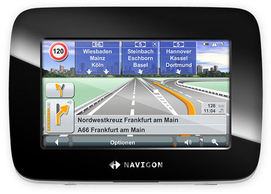
Now for the bit you'll be staring at for most of the time, the HUD during navigation.

sorry for the crappy angle, but it's the only good one i could find
The screen is packed with information, but I, for instance, found it a breeze to make out, while my dad got completely lost. I guess it just takes a different kind of mind. ONTO analyzing!
In the top left, there's a speed limit icon (the pic represents the european version) - this can also be set to warn you with a nice "beware!" if you stray over the limit, and you can set the difference in speed for both built-up or not areas - , next to it the next major road (highway, motorway) you'll be driving on (pops up a few hundred meters away), then in the top right the battery, tmc and satellite icons. Next to those, you can also have a small compass, which shows you the direction you're travelling in (N, NE, E, SE, S, SW, W and NW). I'd prefer it to be a graphical representation with an arrow pointing to north, like in the previous version of the software, though. In the bottom left is a graphical representation of the next intersection you'll be encountering and the distance to it. One thing i HATE about Garmins is that they just say "Turn in xxx m". This one, though, will show you very clearly what you need to do for up to 3 intersections (if they're in close enough succession). At the very bottom (not counting the menu bar), there are 2 lines with street names. The bottom one shows what street or road you're on atm, the one above it shows which one you'll be turning on to in the next intersection. Above that on the right, there are various readouts, which you can set in the options: distance left, time left, time of arrival, speed and altitude (i have them all on). In the middle of the screen is the arrow, which indicates your current position and heading, under it (as can be seen in the pic), is the so-called Lane Assistant, which tells you well in advance which lane to position yourself in for the least fuss in navigating through heavy traffic. There are also a lot of POI scattered on the map (which can also be turned off i think).
That's basically it from the main functionality. I won't list all the features here, i'll only mention the ones which i found the most interresting or a big pain.
Interesting features:
Lack of text to speech. I was initially sceptical about this, but after discovering what a bloody mess the english voices make of it on my dad's Garmin, i don't want to deal with it at all. Not unless they eventually integrate that algorythm, which uses a spatial map of a person's throat to accurately synthesise speech with all its fluctuations and intonations (and incantatsions, if we're lucky). Saw it on one ep of NCIS, looked cool.
There are only a handful of languages to choose from, but the ones that are there (at least the ones i can understand) are of very high quality, the recordings are done very nicely and the sound bites are inter-connected much more smoothly than i've heard of other brands (at least the ones i can understand)
As you drive along, the draw distance will change by increasing the angle of the view. At >90 km/h, you can see the horizon, with a nice blue sky and white puffy clouds in the day mode and a night sky with a few starts at night. That last one isn't really a very important feature, but it is nice.
The last MAJOR feature which i like a lot is the so-called Reality View. This replaces the map view with a pre-rendered illustration of the upcoming multi-lane intersection with arrows guiding you into the right lane. It's basically the previously mentioned lane assistant, but especially meant for highways, where you don't have time to study the screen. The background and certain features like overpasses will change to match what you're actually seeing.
Mobile phone handsfree is a synch to use. It pairs with your phone as any other bluetooth device and offers a nice, simple interface to the basic call functions and call logs, etc...
Painful "features":
Slow panning in 2D map mode, especially when zoomed out a lot. This could be done a lot more smoothly and quickly than it is currently.
As i said in the beginning, the software gets quite buggy if you don't reset it, but the reset also removes the bluetooth pairing, so you have to re-do it and also the volume setting, which is set to 50% and is a big too low for my car (which has a bit of wind noise at higher speeds). I don't know if any of the other features get reset...
And, as before, long calculations for long routes (850 kms to Alok's takes about 30 seconds to calculate).
Overall, i really like the unit. It may be too complicated for some, who just want a simple navigational tool, but i'm a huge gadget freak, so this is perfect. And since i don't know where else to put this: The battery life @ 80% screen brightness, 100% volume in day mode, constant navigation (no stops or recalculating required) and bluetooth connected was 3 hours 10 minutes. The charge time during equal operation was about the same. There are some people in USA (two on this forum as well), who've had a few bad experiences with Navigons taking them on unneccessary detours cross country and similar, but I have to report that during the 2 years that i've had the previous one and the 4000 kms i've done with the new one, not once did it take me anywhere but along the obvious route.
I give it 4.5/5 (which is a hell of a lot more than any other gps device on the market today, at least for this sort of money, which was, incidentally, thanks to Alok Imports, 280-ish euro)
A small reminder, 'Navigon is regarded as the inventor of dynamic GPS invention, a pioneer in mobile Pocket PC navigation systems and the first provider of mobile navigation solutions, including dynamic TMC Stauumfahrung.' (blatantly stolen from wikipedia), so their units will always be on the cutting edge of navigation and i'll attempt to explain at least a part of it here.I purchashed this funky looking thing 2-ish weeks ago and just came home from a week long road trip on which this review is based. So, let's start 2 weeks ago.
The box itself was quite heavy, which I later discovered was mainly down to the 388 page user manual :?. It is in 6 languages, but still... The rest of the contents of the box were as follows:
The GPS unit, the stylish suction mount, a plastic circle with a sticky bottom so you can mount it on a non smooth surface, a car charger, an AC charger, a pouch that fits the GPS unit only and a cd with the manual.
First off, the product is meant to be a GPS unit, not a know all, see all (whatever the phrase is) gadget, like the Garmins, with their mp3 players, dictionaries and converters, etc... The only other feature apart from navigation is bluetooth handsfree.
The unit itself is very nice to look at.
The fascia around the screen, which we'll get to later, is done in glossy black plastic, around that is a chrome edge and at the back, matt dark grey plastic. There are no buttons on the front, only 2 on the right side, 1 is the on/off button, the other switches between the map and main menu. At the back, there is a socket to plug in an external GPS antenna, complete with its own compulsory rubber plug, the circular bayonet slot, and one speaker. At the bottom there are 2 plugs, one is for the TMC antenna, through which the unit receives traffic information and diverts you accordingly, the other is a standard mini-usb plug, which doubles as a charging plug as well. At the top is a slot for an SD card and on the right (on the matt plastic bit) is the slot for the stylus.
The screen at the front is a very nice unit. The view angle isn't as superb as on modern laptops and lcd screens, but seeing as this is a small handheld unit, it's no big deal. It is, however, interlaced, something which i haven't seen in a while. My laptop has one of those screens, but it's quite a few years old. The refresh rate being a maximum of 2 fps (unless you count the animated menus) makes that a moot point. It also only supports 65k shades at a time, but the interface is designed to work around that, with the menus being mostly grayscale icons in the primary colours and their shades. The touchscreen part of it is very nice. My old Navigon GPS and my mp3 player have the soft version, this is the flat, hard one, which handles single point commands very well. It's no iPhone, but then again, it doesn't cost nearly as much.
The mount is very stylish. It's quite big, made out of plastic, with an aluminium core, a big transparent suction cup on one end and a semi-spherical metalic bayonet on the other, which slots into the GPS and can turn in all directions to a certain angle. Mounting the unit onto the mount is very easy once you get the hang of it. It only requires a twist of 45?, then fishing for the hole, once it slots in, level the unit out and it will click into place. The connection is very strong and doesn't shake about. To pull the unit off the mount again, there's a button on the mount, which disengages the lock, and after another 45? turn, the unit is free. The overall size of the mount brings with it a bit of a wobble. The mount itself and the connection are very sturdy, but there's still quite a bit of weight on it and the wobbling is down to the suction cup, which is made out of very soft rubber. It does take going over quite large potholes for the screen to get unreadable. Another thing about the mount, the bayonet, which rotates gets a bit lose after a while (well, it did after a week of almost constant usage), making the unit turn around with bigger bumps or if you try to push any buttons. The designers, however, noticed that and included a little imbus screw inside it (behind the circular plastic plate that says Navigon, which can easily be popped out), and a single turn will make it stiff again. On the trip we also had a Garmin N?vi unit for comparison and its short dinky, ugly little mount remained rock solid throughout the week. There's always a price to pay for trying to be stylish, hehe.
On to the functionality:
The software and the map come pre-installed on the sd card, so as soon as the battery's charging, the unit is ready to go. There are two off modes; sleep and completely off. In sleep mode, the unit remembers your last position and commands, however, since it is based on Windows CE 6.0, it's not recommended to run it like that for a few days at a time. Certain bugs will start to show, like longer route calculation times and inability to load up POI on route or just freezing up. Holding down the power button for 6 seconds will completely turn the unit off and purge the ROM. After you turn it back on, the software needs to be copied into it again and it may take quite a while before that's done and satellites are locked on for navigation to start. After that's done, though, the Navigon unit will quite probably astound people who are not used to it with the ammount of features. The main menu is very simple to begin with, but gets quite complicated the more you dig in. There are 4 big buttons; New Destination (enter an address, search for POI, direct access to 3 POI categories), My Destinations (Favourites, Last Destinations), Take Me Home and Voice Commands. The more comprehensive Route Planner is located in the Options menu at the botom.
New Destination by address works as you would expect. First, already highlighted and pre-set to last chosen entry is the City or Postal code, I guess the creators assumed that the users will be travelling inside the country they're currently located in more often than abroad (which is true, at least in my case). While the City, Street, Number and Cross Street fields are on the left, the alphanummeric+symbol keyboard (switchable between the 3 options) is located on the right. It's in alphabetical order, which takes a while to get used to, if you're used to a qwertz/qwerty/azerty etc layout. Navigation can start immediately after the city has been entered, in which case you will be taken to the city center. As you enter the letters or numbers, the software will automatically suggest all the available entries, starting with those that start with the letter or number sequence you entered, continued by the ones that contain it elsewhere (a very useful feature, cuts down on having to type out the whole name, especially with long german ones like Niedercunnersdorf - which i had to visit this week). The entry can also be viewed on the map, before navigation starts, in which case you can move the crosshair to a desired location and use those coordinates (or address if it's recognized) instead of the one you typed in.
New Destination by Points of Interest works in a similar way, with city, street, number, etc... replaced by category, subcategory and finally name. The map package i got with my unit (entire Europe) comes with 2,126,364 different POIs in 80 categories.
My Destinations by Favourites shows a list of destinations, which you saved either by saving your current coordinates or saving an address or POI in the New Destination dialogue.
My Destinations by Last Destinations is a list of the last 30 destinations chosen for easier access.
You can also append recorded tags to your favourites, which can then be accessed through the Voice Command section. I personally never used it on this trip as I was the passenger, but it might actually come in handy in situations where you can't be arsed to fiddle around with the menus.
Take Me Home is a 1 click navigation to the favourite address which you have designated as your home one.
As stated previously, there's also a 5th button called Options in the main menu, which contains the following selections: Route Planning (very useful), Settings (HUGE ammount of settings in this one, from language, to maps, route profile, reality view, on-screen options, metric or imperial, speed limit warnings, etc etc...), Show Map (shows the map in standard 3rd person perspective), GPS status (time, coordinates, altitude, direction, number of satellites locked on, HDOP (The horizontal dilution of precision) and speed), Traffic warnings and a completely useless (at least from my view) Logbook.
Route Planning basically takes New Destination to a new level, by letting you choose a start point and afterwards any number of stops along the way with an easy interface to change sequence or remove the stops. Of course, you can always Save a Route, but that won't save the calculation, which can take quite a while if the route is very long and has a lot of stops along the way (by very long i mean over 1000 km).
Now for the bit you'll be staring at for most of the time, the HUD during navigation.
sorry for the crappy angle, but it's the only good one i could find
The screen is packed with information, but I, for instance, found it a breeze to make out, while my dad got completely lost. I guess it just takes a different kind of mind. ONTO analyzing!
In the top left, there's a speed limit icon (the pic represents the european version) - this can also be set to warn you with a nice "beware!" if you stray over the limit, and you can set the difference in speed for both built-up or not areas - , next to it the next major road (highway, motorway) you'll be driving on (pops up a few hundred meters away), then in the top right the battery, tmc and satellite icons. Next to those, you can also have a small compass, which shows you the direction you're travelling in (N, NE, E, SE, S, SW, W and NW). I'd prefer it to be a graphical representation with an arrow pointing to north, like in the previous version of the software, though. In the bottom left is a graphical representation of the next intersection you'll be encountering and the distance to it. One thing i HATE about Garmins is that they just say "Turn in xxx m". This one, though, will show you very clearly what you need to do for up to 3 intersections (if they're in close enough succession). At the very bottom (not counting the menu bar), there are 2 lines with street names. The bottom one shows what street or road you're on atm, the one above it shows which one you'll be turning on to in the next intersection. Above that on the right, there are various readouts, which you can set in the options: distance left, time left, time of arrival, speed and altitude (i have them all on). In the middle of the screen is the arrow, which indicates your current position and heading, under it (as can be seen in the pic), is the so-called Lane Assistant, which tells you well in advance which lane to position yourself in for the least fuss in navigating through heavy traffic. There are also a lot of POI scattered on the map (which can also be turned off i think).
That's basically it from the main functionality. I won't list all the features here, i'll only mention the ones which i found the most interresting or a big pain.
Interesting features:
Lack of text to speech. I was initially sceptical about this, but after discovering what a bloody mess the english voices make of it on my dad's Garmin, i don't want to deal with it at all. Not unless they eventually integrate that algorythm, which uses a spatial map of a person's throat to accurately synthesise speech with all its fluctuations and intonations (and incantatsions, if we're lucky). Saw it on one ep of NCIS, looked cool.
There are only a handful of languages to choose from, but the ones that are there (at least the ones i can understand) are of very high quality, the recordings are done very nicely and the sound bites are inter-connected much more smoothly than i've heard of other brands (at least the ones i can understand)
As you drive along, the draw distance will change by increasing the angle of the view. At >90 km/h, you can see the horizon, with a nice blue sky and white puffy clouds in the day mode and a night sky with a few starts at night. That last one isn't really a very important feature, but it is nice.
The last MAJOR feature which i like a lot is the so-called Reality View. This replaces the map view with a pre-rendered illustration of the upcoming multi-lane intersection with arrows guiding you into the right lane. It's basically the previously mentioned lane assistant, but especially meant for highways, where you don't have time to study the screen. The background and certain features like overpasses will change to match what you're actually seeing.
Mobile phone handsfree is a synch to use. It pairs with your phone as any other bluetooth device and offers a nice, simple interface to the basic call functions and call logs, etc...
Painful "features":
Slow panning in 2D map mode, especially when zoomed out a lot. This could be done a lot more smoothly and quickly than it is currently.
As i said in the beginning, the software gets quite buggy if you don't reset it, but the reset also removes the bluetooth pairing, so you have to re-do it and also the volume setting, which is set to 50% and is a big too low for my car (which has a bit of wind noise at higher speeds). I don't know if any of the other features get reset...
And, as before, long calculations for long routes (850 kms to Alok's takes about 30 seconds to calculate).
Overall, i really like the unit. It may be too complicated for some, who just want a simple navigational tool, but i'm a huge gadget freak, so this is perfect. And since i don't know where else to put this: The battery life @ 80% screen brightness, 100% volume in day mode, constant navigation (no stops or recalculating required) and bluetooth connected was 3 hours 10 minutes. The charge time during equal operation was about the same. There are some people in USA (two on this forum as well), who've had a few bad experiences with Navigons taking them on unneccessary detours cross country and similar, but I have to report that during the 2 years that i've had the previous one and the 4000 kms i've done with the new one, not once did it take me anywhere but along the obvious route.
I give it 4.5/5 (which is a hell of a lot more than any other gps device on the market today, at least for this sort of money, which was, incidentally, thanks to Alok Imports, 280-ish euro)


